Sections 1, 2, 3, 4
Section 1 Vienna (Perchtoldsdorf) to Seewiesen
via Baden - Hohe Wand (High Wall) - Mt. Schneeberg - Mt. Rax - Neuberg/Muerzsteg - x - Seewiesen (2007, ~ 18 Days)
Our starting point for "Back to Nice" was the Vienna Suburb Perchtoldsdorf, the very place, where we arrived coming from Nice, three years earlier.
Wonderding about the "x" before Seewiesen? Well, we did not make it that year, and saved the small part for a later time. That did not keep us from starting Section 2 Seewiesen to Altenmarkt anyway - leaving a few white dots (=future) on the overview map.
For many reasons we hiked a little earlier (May 24 to June 15) - perhaps too early, as there were many rainy day interruptions. A little later may be better.
Anyway, we started and made our way towards Baden, through Mödling, and partly along the Beethovenweg to the Rudolfshof, to stay a couple of days for sightseeing. Without a definite planned route, we then visited Pottenstein, Waldegg, and - with local help - made it to the Hohe Wand Park. Eventually, we reached Puchberg, near the Schneeberg (Snowmountain) and a couple of days later, the Waxriegel House at the foot of Rax Mountain. Next day, the weather nice, was devoted to a hike up and around the Rax - defintely a very exciting mountain, with wildlife and views. The rugged trail over rocks and roots was well marked - a pure joy.

From there, partly following the Nord-Alpen-Weg, we reached Altenberg and then Neuberg at the river Mürz (Arnold Schwarzenegger's home territory). Our time allowance up, we "saved" the stretch to Seewiesen for another day.
Section 2 Seewiesen to Altenmarkt (Austria) "<<<"
via Voitsthstaler Hut x Hochschwab x Häuslealm Hut - Sonnschien Hut - Eisenerz - Radmer - Johnsbach - Mödlinger Hut - Rottenmann - Irdning - Altenmarkt (2013 ~25 Days)
Another major section, which we walked eastward, but we describe it in the other direction, to maintain the westward flow of the story.
From Seewiesen (~1000m), a well defined long distance hiking trail "Nordalpenweg" serves as a guide via the Voitsthstaler Hut, across Mount Hochschwab (~2300m, the beginning of the "Alpine Alps" in the East) - Häuslealm Hut - Sonnschien Hut - Eisenerz. In good weather, this is a wonderful tour through dramatic mountain territory, also for many Austrian People, since not far away by car, from Vienna. So, one has company.
From the Sonnschien Hut, one can go West (to Lake Leopoldstein) or South-West, by way of the Gsoll Hut. Unfortunately, this one is not open to the public, requiring to walk an hour to Eisenerz, along the highway. Perhaps you find a bus. The town has its name from the iron ore which was still being mined (2013), in an open pit mountain site. In town one finds many hotels and other lodging possibilities. We stayed in a place west of town, just before a gentle ridge, on the way to the next place, Radmer. We loved that little town, because of its isolated location next to big Mt. Lugauer and because of Mr. Schober, retired schoolmaster and town historian.
He told us about Austria's difficult years since the beginning of WW I, the assasination of the Crown Prince, the decimation of the Austria/Hungarian Monarchy, empire, and society after that war, and the struggle of the people to find a new way. The first promise, under Nazi-guidance, failed terribly. Eventually, after WW II, a new national spirit began to grow, from an unexpected event: The skiing success of Toni Sailer. At age 20, he won all three Olympic Gold Medals in alpine skiing at the 1956 Winter Games, thereby launching his own personal rise to stardom and the country's pride and business in the skiing world.
Mr. Schober had so many other stories - we hope you meet him on one of your hikes. If you do, please say hello from us, the Seiferts.

While the Nordalpenweg continues West near the "Lugauer", we settled on a less strenuous route to Johnsbach, via the Neuberg Alm and Saddle. The next days take you to the Mödlinger and the Oberst Klinke huts, before dipping down to Rottenmann in a major valley connecting Liezen with Graz. One can flee from the traffic by a shortcut through the mountains by way of Oppenberg and the Tonnerhof, reaching Irdning and the river Enns (NOT the En = Inn further west!). Consider a bus side trip to Admont, its treasures, the historic National Library and Monastery Church, and the "Gesäuse", the spectacular narrow gorge carved by the River Enns, nearby.
One time, we had asked for directions, but turned back, fearing some misunderstanding. By coincidence, we met the same people again. They affirmed their earlier recommendation, and told us to "hop in the car" (which was already full, but room was made), stop in their house, for "Kaffeetrinken", and they would then take us a little hotel, actually closed, but they knew the owner, etc ... Very friendly, warm hearted people, another treasure of Austria.
An easy trail without major elevation challenges leads West, mostly on the south side of the river, with views first of Mt. Grimming, later of the Dachstein, before reaching Altenmarkt.
Section 3 Altenmarkt to Zell-am-See (AT) "<<<"
via Flachau - Kleinarl - Bad Gastein - Rauris - Taxenbach - Hundstoa - Zell-am-See (2012 September, ~ 22 Days)
Again, we walked in the other direction but tell it westward. More importantly, since many people had praised the September weather for hiking, we tried that. It was beautiful, even with occasional early snow and noticeably shorter days - in comparison with the June/July season. This entire Pongau area has many hiking trais and routes, including the Salzburger Almenweg, a trail from Alm (mountain farm) to Alm, from which many variations are possible. As always, when aiming for an isolated mountain hut or Alm, one should confirm that the place is in fact open, on that day.
From Altenmarkt one may head to Flachau-Winkl, Hotel Wieseneck, to rest before a major ascent towards Kleinarl, via the Frauen-Alm and a beautiful ridge trail to the Weissenhof-Alm. A steep descent then leads to Kleinarl. There are many ways to go on to Gross-Arl, for example via sections of the Salzburger Almenweg, where we slept at the Muggenfeld- and the very rustic Ellmau-Alm (running mountain water - at a trough, outside.)

It pays to spend an extra day or two in both, Klein- and Gross-arl, to explore the area, get advice for the following days and about the weather. From here over yet another Mountain to Dorfgastein. And again, it is worth spending a couple of days in this valley, especially to visit "Bad" (=Spa) Gastein itself, famous for Kaiser Wilhelm I. of Germany, who has paid perhaps twenty visits to relieve ailments between 1850 and 1888. At the valley's end, built on rugged cliffs, fine high rise hotels have sprung up, especially since the railroad came in 1911. We enjoyed a fancy desert in a cafe with terrace, overlooking the river gorge and waterfalls.
From the valley, an easy trail leads to the Biber Alm hut for a good night's sleep, before crossing over the Seebachscharte (pass, 2200m) to the next, the Rauris valley, also worth exploring. Then, by way of the Kitzloch Klamm (gorge) and Taxenbach one heads to the last major climb up to Mount Hundstein and its summit lodge. Fortunately, there is another lodge Riester Aste, partway up, to just rest or sleep.
Now it is easy, "downhill all the way" to world famous Zell-am-See, and more dramatic scenery all around.
Section 4 Zell-am-See (AT) to Kastelruth (Dolomites, IT) "<<<"
via Pinzgauer Way - Krimml - Birnlücke Pass - Sand im Taufers - Olang - Pragser Wildsee (Lake Braies) - Alta Via Dolomiti (Sennes - Fanes) - St. Cassian - Corvara - Passo Gardena - Wolkenstein - Kastelruth
This is another major section, which we walked eastward, but we describe it in the other direction. Going West, one encounters three significant ascents, actually downhill for us, a little easier. Beautiful alpine territory, all the way, for about four weeks - we take our time.
From Zell-am-See (just South of Salzburg) hikers walk (! - the first major ascent) up to the Schmitten-Höhe (Height ~1900m) and find the Pinzgauer "Spazierweg" (promenade). The name seems to promise an easy ridge trail passing by the Pinzgauer Hut, but, like the other trails of this section, it is a mountain trail, much more than a "stroll in the park". There are dramatic views to the south of the "Ridge of the Alps" with the Great Glockner and the Great Venediger peaks on the other side of the Salzach Valley. One then descends to follow the valley towards the town of Krimmel and its huge waterfalls.
Stay in town and then head South and uphill, to see where all this water comes from, eventually reaching the Hotel/Hostel Krimmler Tauernhouse, at 1600m elevation. Next morning, in good weather, aim for the pass Birnlücke (2660m) - the second of the three major ascents. Here you cross the "Ridge of the Alps", and the border between Austria and South Tyrol, Italy. Fortunately, the Birnlücke hut is only 20 minutes away from the pass, for a well deserved rest.
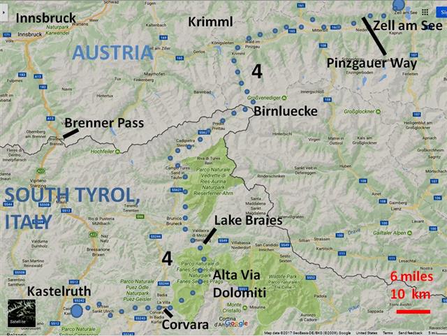
To the West extends the Ahrn-valley (Valle Aurina), your way for the next couple of days, to the town Sand (im Taufers). One may then chose to walk in the valley to Brunico or follow trails along the mountains to the east, heading to Olang, on the way to the Dolomites, especially the Pragser Wildsee (Lake Braies). Hopefully, you stay in the historical Hotel, in the park, directly at the lake, because, in good weather, you now face the third big ascent to the Ofenscharte pass at 2400 meters. You have now tasted the rugged rocks of the Dolomites. Not far away from the pass there are two hostels (Biella, Sennes) - to rest, eat, sleep.
Heading south on the Alta Via Dolomiti #1, one finds two more lodges (Pederu and Fanes). Take the time to stay the nights, and enjoy the famous, wild landscapes all around you. Continue the #1 to the Lagazuoi hut and further, or bow out to the right (easier), to St. Cassian. Next day, you reach Corvara, in another, across the Gardena Pass, Selva and Wolkenstein and yet another, by way of Ortisei, Kastelruth.