Sections 8, 9, 10
Section 8 Lugano (CH) to Omegna (IT) (2016)
via - Porto Ceresio - Brinzio - Laveno - Lago Maggiore - Stresa - Omegna
Getting yourself to Lugano from the North involves crossing the Alps - and that takes a full day. Fortunately, there is a nice hostel 10 minutes from the train station. We stay a few days to find trails to the East - to connect to last year's end point and to explore "mouse holes" for hiking out of the city to the South, via San Salvatore, Lugano's "house-mountain". Stubbornly we refuse the funicular and walk up (700 v. m) - very enjoyable - then down the South side. A local bus takes us to the hostel and next day, back to the trail ("legal" for us - we make the laws).


Toward Morcote, note the trail sign, left.
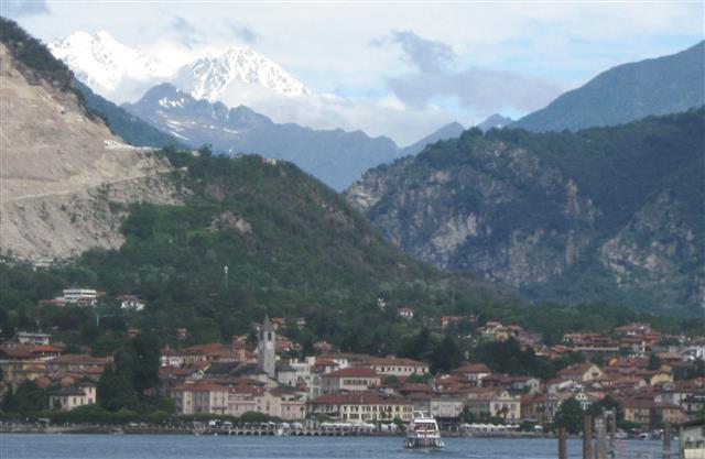
A wide ridge trail leads to Morcote where the boat stops later for the ride (no walking on water) to Porto Ceresio (IT). We use the wait to see the sites, take pictures and enjoy "Kaffeetrinken". We feel like on vacation. Across the lake, in Italy, after very friendly advice from many sources, we find the hotel, plot our course for the next days, eat, sleep, breakfast ... we are on our way.
Finding the trail through the populated area takes some guessing, but soon we judge "this must be it", from the mud before us .... It takes us up a ridge and with more guesses like "this must be leading somewhere" we find Alpe Tedesco - however, no beds to be had there - too early in the season. It is not far to the next little town, along a narrow very steep road, down to Valganna, and an old, small hotel ... just fine for us.(See picture below) Then, on through gentle rolling hills in several days, via Brinzio, Citiglio to Laveno at Lago Maggiore.

In contrast to Switzerland, this area's economy has slowed. Not unlike the Northeast inAmerica, its boom era was more than a hundred years ago, when local electric trains brought tourists and business, and solid stone houses testify to a rich past. If we hiked there again, we would perhaps take in the high ridge Campo del Fiore and the Cathedral of Santa Santa Maria el Monte. But, because of strong rain that day, we made it a bus round trip and stayed an extra night in Brinzio. Next morning, weather clear again, we walked on to Cittiglio and Laveno, at the Lago Maggiore.
By ferry, with great views (see below), Laveno - Intra - Isola Bella - Stresa, all beautiful vacation and tourist Meccas, find a hotel and explore the surrounding area. The path across the majestic Mt. Motarone impractical (construction, closures), we continued at lake level to Feriola, even though, at this lake, hikers are an anomly and trail signs few. Tour busses and groups, the Ferrari club, huge 5-star hotels, and private mini-castles at the waterfront, with view of the Alps - all this is big business here. But we "did our thing" anyway and find Omegna (on Lago di Orta), in preparation for Section 9 from here to Alagna Valsesia, further West. This year, we had allowed only two weeks of hiking - so Omegna was the end point.
From Lago Maggiore, view to NW, with Monte Rosa in the background, top left
On our way home, we detour by train and bus to see Macugnaga, at the foot of Monte Rosa (4,600 m or 15,200 ft), the peak 10,000 ft above the little town at valley's end. Only one mountain pass separates this town from the destination of section 9. However, distance without hostels and elevation difference (1300 m up and also down) are too great for us.
Next year, we skip a small section 9, eager to make faster progress to Courmayeur, at the foot of Mt. Blanc.
Section 9 Omegna to Alagna Valsesia and Gressoney (2018)
planned, via - Val di Forno - GTA - Rimella - Alagna Valsesia - Gressoney
This is actually a relatively short stretch, about 70 km (50 mi). It starts along a valley (Val Strona) from Omegna to Forno and Campello Monti, where one meets the Grande Traversati delle Alpi (GTA), a well defined long distance trail from Switzerland to the Mediterranean Sea so that one might safely make it to Alagna Valsesia, Valdobbia and the Vogna valley to the Rifugio Sottile. The latter was familiar to us, because we had already seen it from the Gressoney side in 2017. The GTA, combined with Via Alpina Stages 131 to 135, allows detailed planning, HOWEVER, on our fourth day, we found the trail was too difficult and hard, several passes reported snow cover, and a hostel was still closed due to snow. With a heavy heart we took the bus (!) to Alagna Valsesia and enjoyed wonderful day hikes at the foot of Monte Rosa.


1 Omegna > Forno
2 Forno > Campello Monti > Forno
3 Campello Monti > Rimella
4 Rimella > Santa Maria di Fobello
5 Santa Maria di Fobello > Carcoforo
6 Carcoforo > Rima (intermediate stop)
7 Rima > Rifugio Ferioli
8 Rifugio Ferioli > Alagna Valsesia
9 Alagna Valsesia > San Antonio di Valvogna
10 S. Antonio > Rifugio Sottile (Colle Valdobbia)
11 Sottile > Gressoney
http://www.via-alpina.org/en/stage/132
(by bus)
(roundtrip day, to warm-up)
#131A
#131B (stopped here)
#132
#133A
#133B
#134A (partial)
#134B
#135 (partial)
(future?)

Then, we skipped again by bus (!) from Alagna to Courmayeur to continue "work" on Section 10.
Section 10 Gressoney IT to Chapieux FR (Partial, 2017, 2018)
via - Val d'Ayace - Valtournanche/Cervinia - Valpelline/Ollomont - St.Rhemy - Frassati Hut - Bonatti Hut - Courmayeur - Chapieux FR
We are now in the North-West corner of Italy, in the Aosta Valley*. It stretches East to West approximately just between the words "Zermatt" and "Briancon", on the Map. The valley's major river "Dora Baltea", originates at Mt. Blanc, near the town Courmayeur, flows East. Its northern Tributaries spring from "The Ridge of the Alps" and have created major now famous valleys. That is where we hiked this year, for three weeks, from the end of June to the midlle of July. A most wonderful experience.
Two trails extend from East to West along the valley, #1 North and #2 South of the Dora Baltea. The latter one leads through the Gran Paradiso National Park. The former (#1) parallels the Alpine Ridge and the huge and famous peaks, like Grand Combin, Matterhorn, and Monte Rosa, along the border to Switzerland. The trails are among the best maintained, marked, described, and practical for long distance hiking.
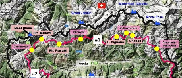

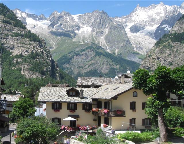
For us, now aged 81 and 79, some of the daily stretches were too demanding - requiring 1000 meters (3300 feet vertical) ascent and/or descent. That is why on this first visit to the area, we chose not to cross over the mountains, which separate the valleys - "too hard". Instead, from a given valley, we walked up about halfway - and back down, towards the east, and next day, west. Then, we traveled by bus to the neighboring valley ... and so on. That is why, on the map, we have the white intermediate dots. You see that we have "softened up". Below, Mt. Blanc Massiv, from Cournayeur.
Pondering now whether to go back and that time follow the trail across the mountain passes, satisfied of the trails' excellent condition and demarcation. Essentially, in good weather, one cannot get lost. And, one always finds something delicious to eat.
Thank you, Aosta.
In 2018, within the hour of arrival in Courmayeur, we set out to explore the southward trail, to the Elisabetta hut and the pass to France, Col de la Seigne (2516 m). On the way, we spoke with several hikers and groups who had made the crossing. For us, there was still too much snow - some might melt in a few days and, optimistically, we already made a reservation in the hut near the pass. This is dramatic territory - no problem to fill the three, four days with other hiking adventures to mountain hostels like Lavachey, Bonatti, Helena, Bertone - always with an eye on the conditions of "our" pass to the South.


In fact, they did improve, and the weather forecast was reasonably good: clear mornings, rain late: Start early, be at a hostel by noon.


Perhaps as the authors of "Hike For Your Life" (or was it just old age?) we were afforded a degree of celebrity and "upgraded" from "dorm, 25/room" to a private room - when by 7:30 p.m. there was a no-show. The place being packed with hikers, privacy was an enormous benefit. Thus well rested, we set out after breakfast and reached the Col de la Seigne after an hour.


There were already many mostly younger hikers, from all corners of the world. Opportunity to share with "Omi and Opa" stories of peace, mountains, and love. A great highlight.
Two or three more hours brought us to Les Mottets FR, a private hostel, where we received a fine dinner and yet another privileged sleeping spot.


The next day, a few more hours downhill brought us to a real hotel, with private hot shower and other creature comforts in Chapieux. The picturesque village of about five houses and the cheese store looked the same as twenty years ago. Time for a big hug and a few tears of joy - before departing the next day for Bourg St. Maurice, and the way home (Summer 2018).