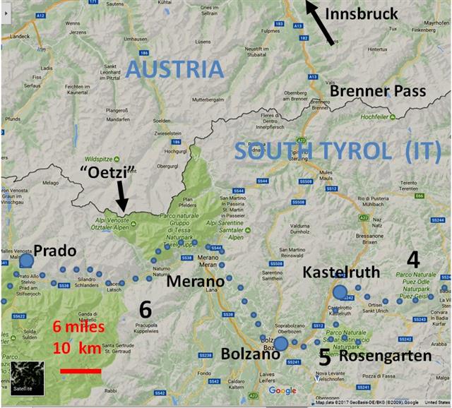
Sections 5, 6, 7
Section 5 Kastelruth to Bolzano (IT, South -Tyrol) "<<<"
via Ums - Tschafon Hut - Tiers - Breien - Steinegg - Bolzano
This is a very short section, which we describe westward, with the flow of the story. In this case, westward is more downhill (net), easier. As the "<<<" indicate, we actually walked in the other direction.
Kastelruth lies at the foot of the Schlern (Mountain) and is known for a Singing Festival and the claim (contested) that the medieval (~1200) German Poet Walther von der Vogelweide was born nearby.


Skirting the "Schlern" on its west side, one walks south towards Ums and, next day, uphill to the wonderfully old-fashioned Tschafon Hut. Omi and Opa had started this business in the early 1950s. It was very hard, until about 1956: Then, they got a donkey, to carry the water from the well to the hut ...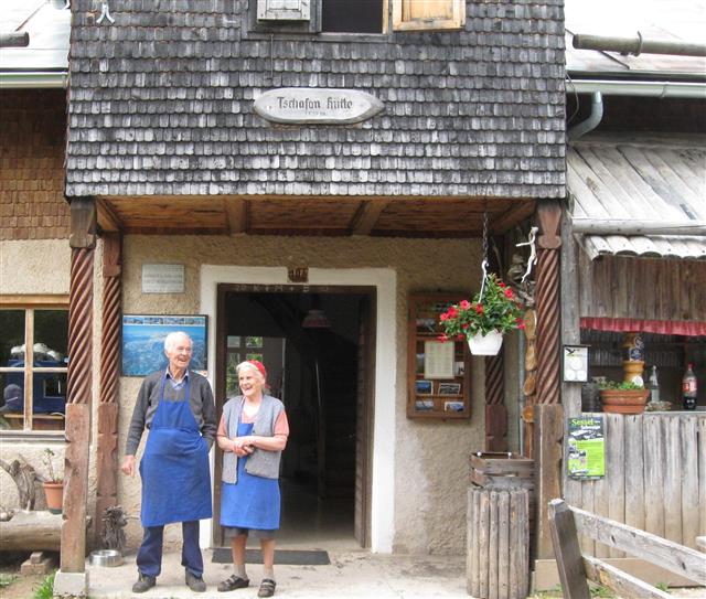 Tschafon Hut w. Owner-Founders
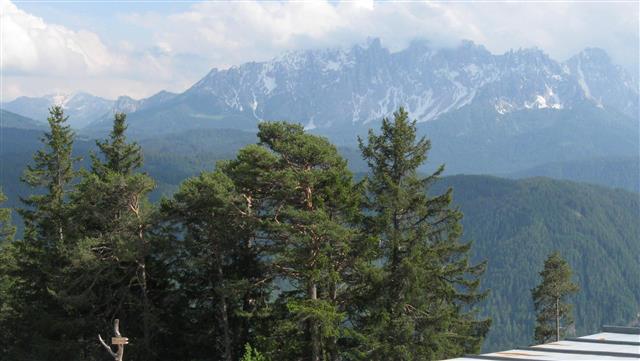 View of the Latemar Range
A little side trip to the Völser Spitzl (point) rewards the visitor with a tremendous view to the south and west, with Bolzano recognizable in the distance. Bring camera and binoculars. One may stay at the hut or descent to St. Cyprian or Tiers and enjoy excellent views of the famous Rosengarten and Latemar Mountains nearby.
The more adventurous may walk from Kastelruth over the Schlern, and spend the night at the Hostel near the top. The opportunities are to descend via the Tschafon Hut or other routes via the Rosengarten to Tiers.
From there, via Steinegg, one reaches Bolzano. The trail "Perlenweg" (Trail of Pearls) was not always marked, but, being close to "civilization" and "restauration" this was not a problem.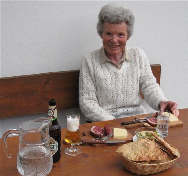
Rustic Dinner in Steinegg
Section 6 Bolzano to Prado (Furkel Hut/Stelvio Pass) (2013)
Via the Albergo Stella Alpina - Hafling - Dorf Tirol - Hochganghaus - Naturns - Silandro (Schlanders) - Laas - Prado - Stilfs - Furkel Hut
Visiting the Bolzano Ice-Man (Ötzi) Museum, our hiking-friend noticed why our old back packs (1975) were so successful: Their design (Frame, Straps, Bags) matched that of Ötzi's back pack, of 5000 years ago. Thus encouraged, we walked the 1000 meters up to Genessee (Albergo Stella Alpina) and the next several days to Haffling, Dorf Tirol, Hochganghaus, to Parcines.
At a different occasion, we covered the distance to Prado along the prosperous Adige (Etsch) river valley, whose older inhabitants still feel a loyalty to Austria - their guardian up to a hundred years ago.
Without strenuous climbs one simply enjoys the results of the people's dedication to daily work: Huge plantations of apples, pears, peaches, vineyards, and more, you name it. Neat and clean villages, towns, restaurants, private little hotels, marble processing, and the tiniest ancient churches, as old as 1400 years. Treasures all around:
 Ancient Churches: Crypta Marienberg
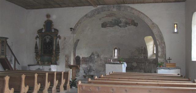 St. Veit
Eventually, we walked towards the pass, to the village of Stelvio (Stilfs), enjoyed a day there, and continued along an unpaved road (oh, had there only been more signs) to the Furkel hut. For hikers to the Stelvio Pass this is a crucial overnight stop - but, there are not enough of us, to keep it going. So, one takes the chairlift down, the bus to a hotel in Prado or Stilfs, and next morning rides up again - to continue the hike to the Pass. For us, that would be next year (2015, Section 7)
Section 7 Prado (Furkel Hut/Stelvio Pass, IT) to Lugano (CH) (2015)
via - Cancano IT - Viola and Bernina Passes - St. Moritz CH - Maloja Pass - Soglio - Chiavenna IT - Lago di Como - Menaggio - Lugano CH
Having visited and explored this area of Southern Tyrol several times, a hiking route had taken shape in our minds - with only one great uncertainty: Snow at the Stelvio Pass ?
So, in 2015, our first day was dedicated to finding out. We took only day-packs and went by bus and chair lift from Prado to the Furkel hut, the end of our last segment. From there, the famous Goldsee [Golden Pond]-Trail leads us 800m up to the Garibaldi Hut, at 2800m. Soon we meet the first people coming down - a very good sign. They report some snow, yes, but passable.
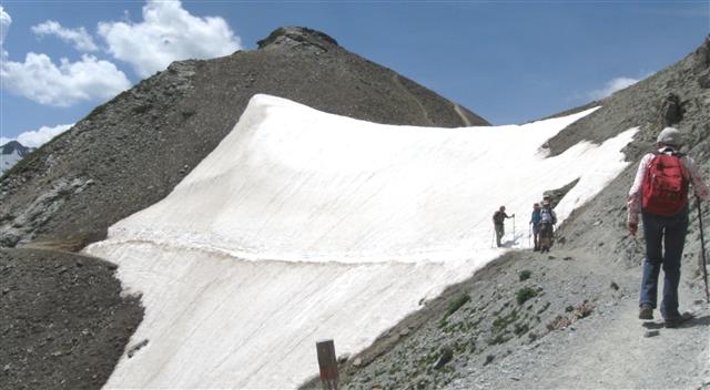 >
>
Without a well compacted track, this snow field would have been a NO-NO. Or mean to scramble, if safe, around the snow. But, this looked OK, so we went across, carefully, like the other people. An hour or so later, we enjoyed "Kaffeetrinken" at the Garibaldi hut and walked down a little to catch the bus for Prado to sleep in our economical hotel. Next morning, again by bus (with the hotel's free local mobility card) it is back up to the pass, with all our gear.
Another similar "ridge" was free of snow so that we could confidently walk toward the Cancano lakes and our reservation in the only place around - it was farther than we thought.


The third day brought us to the hostel at the Viola Pass, the border to Switzerland. Hiking then toward Poschiavo would have been easy, but we took a proverbial shortcut to stay on elevation. We lost the trail, scrambled around cows, and too late to turn back, in light rain, we fled forward - this turned out to be correct and we found a fine little hotel La Rosa for dinner, bed, and breakfast.
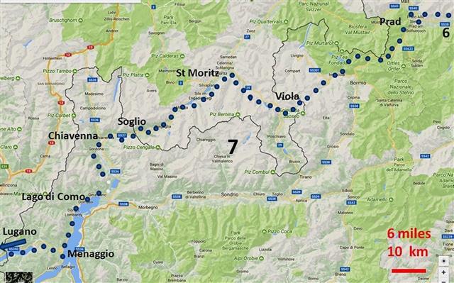
(Map courtesy GOOGLE MAPS, non-commercial use)
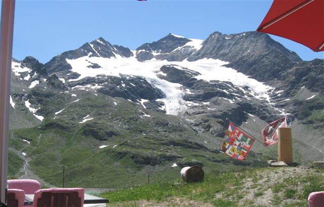
For several days, we made good progress to the Bernina Pass (2500 m, pic below)
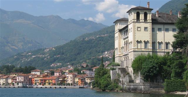
Pontresina, Silva Plana and along the lakes of the En-Gadin (Valley of the river Inn) to Maloja, Vicosoprano, Soglio, and Chiavenna, a major stop, along the "Strada Regina" a roman or medieval "superhighway" now a trail, leading "down the southern slope of the Alps". Which way to go now? At one point, the trail simply vanished for several miles - so we resorted to a bus to find the continuation in Gera, on the West side of Lago di Como.
Now at 200 m elevation, we coasted level along the lake, a vacation paradise, eventually reaching Menaggio. We did walk every single step - but allowed ourselves to shuttle by bus back to the hotel, several times ("age, heat"). The trail from Menaggio to Lugano needs a little attention - but the landscape is so romantic and loaded with historical references - that we were happy to call Lugano as the end, even though the bus helped again for the last six miles. We'll walk them next year.